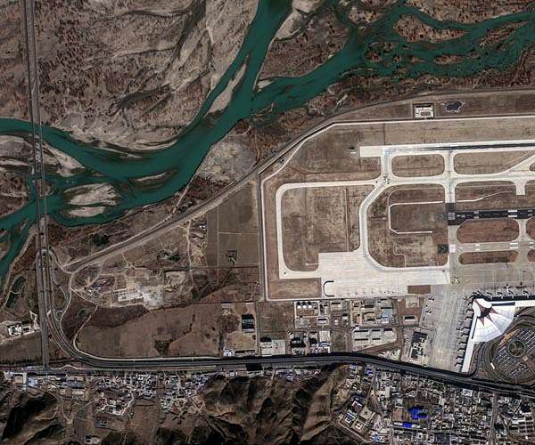
Planet Labs has released the first image, received from its satellite DZZ Pelican 6, showing Lhasa Gonggar International Airport in Tibet, and the image characteristics of the new spacecraft are revealed.
Pelican Satellite 6 is part of Planet's Pelican constellation, fleet of next-generation Earth observation spacecraft, designed to obtain high-resolution images with the possibility of rapid re-viewing and wide global coverage. First images, usually, are mission benchmarks, which show the quality of sensor calibration, imaging chain integrity and ground processing workflows during early satellite operations.
The published image shows the airport and the surrounding area in detail, contrast and clarity, sufficient to distinguish runways, terminals and nearby topographic objects. Planet claims, that the image contains data from several spectral bands, used in their standard analytical products.
Planet's Pelican series is designed to support a range of commercial and government needs, including infrastructure monitoring, detection of changes in land use, responding to natural disasters and assessing the state of the environment. Data from Pelican 6 will be combined with images from previous Pelican satellites in the Planet analytics platform, which will ensure frequent data updates for customers, which require near-real-time Earth observation.
The first images are usually obtained shortly after the spacecraft is put into operation, giving operators and customers the first operational insight into sensor performance over known ground targets. These images are often used to refine geolocation alignment, radiometric calibration and image processing pipelines.
The Pelikan constellation operates in a low Earth orbit with a sun-synchronous trajectory, which allows daily repeated visits over the mid-latitude regions. Quick return visits are a key opportunity for customers, which track dynamic environmental or economic events, related to agriculture, urban growth or resource management.
Planet's data subscription services provide access to analytical products, obtained on the basis of raw satellite images, including orthorectified mosaics, change detection layers and specialized analytics for customers.
Source: https://www.spacedaily.com