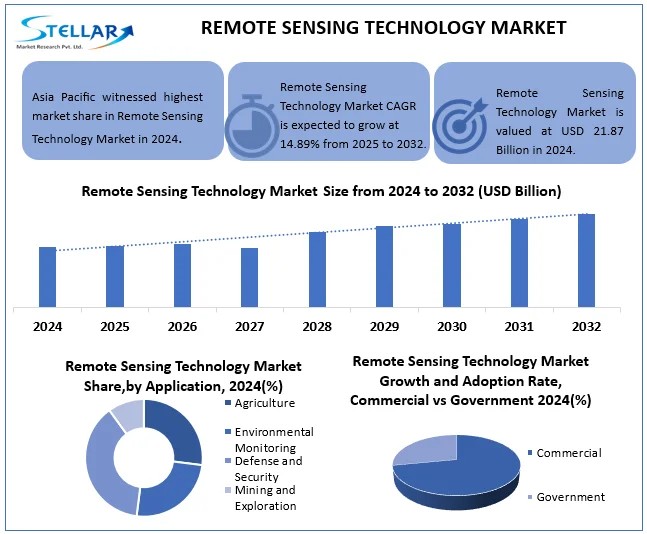
The market of remote sensing technologies is developing rapidly and, according to forecasts, will grow from 21,67 billion dollars in 2024 year before 65,80 billion dollars to 2032 year, showing an average annual growth rate (CAGR) 14,89% in the period of 2025 by 2032 year. This progress is due to the growing demand for climate monitoring, improvement of agriculture, integration of artificial intelligence, the appearance of new satellites and drones, development of smart cities, government funding and lowering the cost of technology, which provides faster and more accurate analysis of Earth and space data.
Dynamics of market development
Technological innovation plays a key role in the expansion of the remote sensing market. Progress in the creation of compact satellites, such as CubeSats, and improved drones with longer flight times, high-precision sensors and autonomous capabilities allow you to get detailed data at a lower cost. Example, the Indian company Pixxel launches high-resolution color satellites, and drones provide local monitoring for agriculture, ecology and safety. The integration of artificial intelligence improves data analysis, and blockchain technologies increase their security.
However, the market still faces challenges, related to data privacy and security. Strict regulations, such as GDPR, and public concerns about the ethical use of data require transparency and robust protection. New initiatives, such as the EU Space Data Management Act, aimed at solving these issues, ensuring compliance with increasing security requirements.
Segmentation and regional features
The market is divided into several key technologies: optical remote sensing, radar sounding, LiDAR and hyperspectral imaging. Optical sensing leads the way thanks to high image quality, which are widely used in agriculture, forestry and land monitoring. New developments, such as Taiwan's resolution satellite 2,5 meters and the Chinese group of Beijing-3C satellites, strengthen this segment, and integration with artificial intelligence increases the accuracy of the analysis.
North America remains the market leader due to the developed infrastructure, significant government investment from NASA and the US Department of Defense, as well as activities of leading companies, such as Maxar Technologies and Planet Labs. The Asia-Pacific region is showing the fastest growth due to rapid urbanization, state programs, like ISRO and Gaofen, and the emergence of private space companies, such as Pixxel. Europe is in third place thanks to the Copernicus program from the European Space Agency and cooperation with Airbus, with an emphasis on climate monitoring.
Recent achievements
Among the notable events – India's Pixxel plans to launch the first private group of three-color satellites on a Google-backed SpaceX rocket, with ambitions to expand the fleet to 18 satellites. Albedo company in March 2025 launched the Clarity-1 satellite with resolution 10 cm and plans to expand the group to 24 devices, which strengthens the potential of the satellite imagery market, estimated in 19 billions of dollars.
Competitive environment
The market is competitive, with key players, such as Maxar Technologies, Lockheed Martin, Planet Labs, L3Harris Technologies, Northrop Grumman, Ball Aerospace, BlackSky, Capella Space, Spire Global, Orbital Insight і Descartes Labs. These companies focus on improving technology, expanding market presence and cooperation with public and private partners to develop new applications.
Source: https://www.einpresswire.com